I Hug Trees

Satellite Monitoring & Remote Sensing

Tree Conservation from Space – Weekly

Tracking forests, urban trees, and carbon from orbit — weekly insights on remote sensing and satellite analytics for tree conservation.

📅 2026-04-03 ⏱️ 13 min read 🛰️ Weekly

Week of 2026-04-03

Satellite Monitoring & Remote Sensing

Tracking forests, urban trees, and carbon from orbit — weekly insights on remote sensing and satellite analytics for tree conservation.

This Week's Highlights

Satellite monitoring and remote sensing are revolutionizing tree conservation, providing unprecedented insights into forest health and urban green spaces. This week, we delve into significant advancements such as the use of Planet satellite data for monitoring tropical forest carbon stocks and emissions, and the integration of AI with satellite data to enhance urban tree canopy monitoring. Major themes in this edition include carbon stock assessment, deforestation detection, and the application of data analytics tools in forestry. ihugtrees.org, a key player in satellite monitoring and remote sensing for urban trees and desert greening, tracks these developments to offer practitioner insights and foster data-driven conservation strategies. We explore how new satellite imaging techniques are tracking deforestation tree-by-tree and the impact of Amazon deforestation on surface temperatures. This digest provides a comprehensive view of the latest scientific reports and technological innovations driving global tree conservation efforts.

Satellite monitoring of forest canopy from orbit

Satellite monitoring of global forest canopy. Photo: I Hug Trees / ihugtrees.org

Understanding Satellite Monitoring for Tree Conservation

What is Satellite Remote Sensing and Why Does It Matter for Trees?

Satellite remote sensing is the science of measuring and monitoring Earth's surface from orbit — without physically visiting the location. For tree conservation, this capability is transformative. Satellites equipped with optical, multispectral, radar, and LiDAR sensors can measure forest extent, tree canopy density, vegetation health, above-ground biomass, and carbon stocks across millions of hectares simultaneously. Indices like NDVI (Normalized Difference Vegetation Index) turn raw spectral data into actionable insights: is this forest stressed? Is it losing cover? Is that reforestation project actually working?

The stakes are high. Forests cover roughly 31% of Earth's land area and store approximately 560 billion tonnes of carbon. Monitoring them at scale is impossible through ground surveys alone. Satellite data from platforms like NASA's Landsat and MODIS, ESA's Sentinel constellation, and commercial providers such as Planet Labs now makes near-real-time global forest monitoring a reality. At ihugtrees.org, we apply these tools directly — tracking urban tree canopy change and monitoring desert greening outcomes through satellite data analytics.

How Do Satellites Monitor Trees — and What Can the Data Tell Us?

Different sensors reveal different dimensions of forest health. Optical satellites capture reflected sunlight to map tree cover, detect species composition, and compute vegetation indices. Synthetic Aperture Radar (SAR) penetrates cloud cover — critical in tropical regions — and measures forest structure and biomass. LiDAR instruments like NASA's GEDI mission fire laser pulses to reconstruct precise 3D canopy architecture, enabling accurate carbon stock estimates at global scale. Combined with AI and machine learning, these data streams power automatic deforestation alerts, urban canopy inventories, and restoration verification systems.

The analytical layer is equally important. Platforms like Google Earth Engine allow scientists and conservationists to process petabytes of satellite imagery in the cloud without specialised hardware. Open-source tools such as QGIS, SNAP, and Python-based libraries democratise access further. The result: a growing community of practitioners — including community organisations, NGOs, and platforms like ihugtrees.org — can now deploy satellite analytics for local conservation action, not just large institutions. This weekly digest tracks the frontier of that expanding capability.

NDVI & Forest Health Monitoring

Satellite NDVI image showing forest health and vegetation density

Photo by pasja1000 on Pixabay

The 
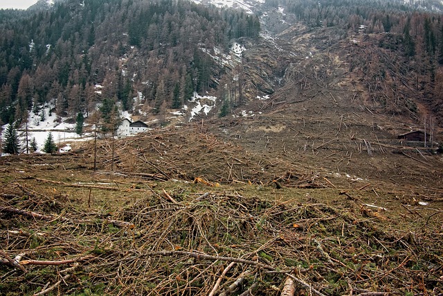
Normalized Difference Vegetation Index (NDVI) is crucial for assessing forest health by analyzing the difference between near-infrared and red light reflected by vegetation[1]. Satellites like Sentinel-2 and Landsat provide high-resolution data that enable detailed NDVI analysis[2]. This analysis helps in detecting vegetation stress, which can indicate issues such as disease, drought, or deforestation. By monitoring seasonal changes, forest managers can track growth patterns and identify periods of stress[3]. This proactive approach allows for timely interventions to mitigate potential threats to forest ecosystems.

Advanced applications of NDVI, combined with AI and hyperspectral imaging, offer even more precise monitoring of tree health from space[4]. These technologies can identify subtle changes in forest conditions that may not be visible to the naked eye. For instance, variations in NDVI values can signal early signs of stress, enabling targeted conservation efforts[5]. This integration of remote sensing and artificial intelligence represents a significant leap forward in forest health monitoring, providing valuable data for sustainable forest management practices globally.

In summary, NDVI analysis, enhanced by satellite data and AI, offers a robust solution for monitoring forest health. It enables the early detection of stress factors and supports informed decision-making in forest conservation and management.

Deforestation Detection & Alerts

Satellite imagery detecting deforestation and forest loss

Photo by mmisof on Pixabay

Real-time deforestation alerts are critical in combating illegal logging and forest cover loss, particularly in the Amazon and other tropical regions[1]. Satellite-based systems like Global Forest Watch, PRODES, and DETER offer precise monitoring and quantification of deforestation[2]. These systems utilize advanced algorithms and satellite imagery to detect changes in forest cover, providing near-real-time data that can be used to issue alerts and inform conservation efforts[3]. The integration of these technologies allows for more effective enforcement against illegal activities and helps in assessing the impact of deforestation on global ecosystems[4].

The PRODES and DETER systems in Brazil are particularly notable for their role in monitoring the Amazon rainforest[5]. PRODES provides annual deforestation data, while DETER offers near-real-time alerts, enabling rapid response to deforestation events[2]. These systems not only help in quantifying forest loss but also in understanding the environmental impacts, such as increased surface temperatures during the dry season[3]. The data from these systems are crucial for policymakers, conservationists, and researchers to develop strategies for forest preservation and sustainable management[4].

Urban Tree Canopy Mapping

Aerial view of urban tree canopy and city green cover

Photo by WikiImages on Pixabay

Urban tree canopy mapping is essential for maintaining and enhancing city green cover. This process involves analyzing aerial and satellite imagery to create detailed maps of urban tree canopies[1]. By utilizing Geographic Information Systems (GIS) and artificial intelligence (AI), cities can conduct comprehensive street tree inventories[2]. These technologies enable precise monitoring and management of urban forests, contributing to the mitigation of the urban heat island effect[3]. Organizations like ihugtrees.org exemplify this work by actively employing these methods to monitor and promote urban tree health and coverage[4].

The integration of AI with satellite data allows for more accurate and efficient urban tree canopy analysis[1]. This combination helps in quantifying carbon stock and understanding tree community composition within urban environments[3]. Advanced models like BiFPN-YOLOv8m further enhance tree counting capabilities using satellite remote sensing data[5]. These innovations not only support urban planning but also foster global efforts to combat climate change by increasing urban green spaces[4].

LiDAR & 3D Forest Structure

LiDAR 3D point cloud map of forest structure and canopy height

Photo by pasja1000 on Pixabay

Airborne and spaceborne LiDAR technologies are revolutionizing our understanding of 3D forest structures. By capturing detailed 3D point clouds, LiDAR provides precise measurements of canopy height models and above-ground biomass estimations[1]. The NASA GEDI mission exemplifies this, offering unprecedented insights into forest canopy heights and carbon stocks across the globe[2]. These data are crucial for quantifying carbon stock and assessing tree community composition in various forest types[3].

Drone LiDAR surveys complement these efforts by providing high-resolution, localized data that enhance the accuracy of biomass estimations[4]. When combined with satellite imagery, such as Sentinel-2, these surveys enable multi-seasonal monitoring and detailed urban tree species identification[5]. This multimodal approach leverages the strengths of both airborne and spaceborne LiDAR, resulting in comprehensive and reliable forest structure assessments.

The integration of LiDAR data with machine learning algorithms further refines aboveground biomass estimations, particularly in mixed temperate forests[2]. This synergy of technology and data science holds great promise for advancing forest management, conservation efforts, and climate change mitigation strategies worldwide.

Carbon Stock Assessment

Forest carbon stock measurement using satellite remote sensing

Photo by WikiImages on Pixabay

Satellite-based forest carbon stock estimation has revolutionized REDD+ monitoring and verification, providing precise above-ground biomass mapping[1]. Utilizing advanced remote sensing technologies, national forest inventories are now more accurate and comprehensive[3]. This approach allows for the detailed measurement of carbon credits from orbit, enhancing the credibility of carbon trading markets[4]. By integrating satellite data with machine learning algorithms, we can achieve unprecedented levels of detail in forest carbon assessments[2]. This synergy not only improves our understanding of forest dynamics but also supports effective climate change mitigation strategies[5].

The integration of satellite imagery with ground-based data enables real-time monitoring of forest health and carbon storage[1]. This dual approach ensures that carbon stock assessments are both robust and scalable, catering to global needs[3]. Furthermore, the use of multimodal remote sensing observations enhances the accuracy of above-ground biomass estimates, crucial for REDD+ initiatives[4]. These advancements are pivotal in verifying carbon credits, ensuring that they reflect true ecological contributions[2]. As we continue to refine these technologies, their role in national forest inventories becomes increasingly vital[5].

In conclusion, the fusion of satellite data and remote sensing offers a powerful toolset for carbon stock assessment. This technology-driven approach not only supports global climate goals but also empowers nations to manage their forest resources more effectively[1][3][5]. As we move forward, continued innovation in this field will be essential for maintaining the integrity of carbon markets and promoting sustainable forest management practices worldwide[2][4].

Biodiversity & Habitat Monitoring

Satellite habitat map showing forest biodiversity and ecosystem connectivity

Photo by jplenio on Pixabay

Biodiversity and habitat monitoring are critical for preserving ecosystems and species worldwide. Satellite technology plays a vital role in species habitat mapping, enabling precise identification of areas where different species reside[3]. Forest fragmentation analysis via satellite imagery reveals the extent of human impact on natural habitats, highlighting regions where ecosystems are most threatened[1]. Monitoring protected areas with satellite data ensures that these crucial zones are effectively managed and preserved[4].

Ecosystem diversity assessment from space allows for a comprehensive understanding of the variety of life within different habitats[3]. Detecting connectivity corridors through satellite imagery helps identify essential pathways that allow wildlife to migrate and interact, promoting genetic diversity and resilience[5]. These advanced monitoring techniques are essential for informed conservation strategies and sustainable management of our planet’s rich biodiversity[4].

Reforestation & Restoration Tracking

Reforestation and restoration tracking have become critical in assessing the success of global reforestation efforts. Satellite verification plays a pivotal role in monitoring tree planting and the progress of initiatives like the Bonn Challenge[1]. By leveraging advanced satellite analytics, organizations such as ihugtrees.org are able to provide precise data on reforestation success and desert greening efforts[3]. This technology allows for the continuous tracking of restoration sites over time, offering valuable insights into afforestation performance and ecological recovery. Satellite data integrity ensures that reforestation efforts are accurately assessed, highlighting areas of success and those needing intervention[4].

The use of satellite mapping has revealed significant underestimations in tropical tree cover losses, emphasizing the need for improved global tracking mechanisms[2]. Companies like Nestlé are now piloting cutting-edge satellite technology to enhance transparency in their reforestation projects, demonstrating a commitment to verifiable and sustainable practices[5]. This approach not only aids in the assessment of current efforts but also informs future strategies for effective forest restoration. The integration of satellite data with on-the-ground efforts ensures a comprehensive understanding of reforestation impacts and progress.

Overall, the combination of satellite verification and ground-level data fusion represents a robust framework for monitoring and enhancing reforestation and restoration initiatives worldwide. This technology-driven approach ensures that efforts are both transparent and effective, ultimately contributing to the global goal of reversing ecological collapse and promoting sustainable land use practices.

Data Analytics Tools & Platforms

Data analytics dashboard for satellite forest monitoring

Photo by jplenio on Pixabay

Data analytics tools and platforms have revolutionized the field of environmental monitoring and conservation. Google Earth Engine, an open-source GIS tool, provides unprecedented access to satellite data, enabling detailed analysis of forest carbon stocks and emissions[1]. This platform allows researchers to monitor tropical forests in real-time, offering insights into canopy height variability and deforestation rates. Additionally, machine learning algorithms are increasingly used for forest classification, enhancing the accuracy of species identification and health assessments[2]. Cloud-based satellite data platforms facilitate the integration of vast datasets, making it easier to track changes over time and across regions.

AI-driven tree detection systems have further advanced the capabilities of remote sensing analytics. For instance, Purdue University's digital forestry team employs AI to monitor urban trees, providing valuable data for urban planning and conservation efforts[4]. Similarly, deep learning models like BiFPN-YOLOv8m are used for precise tree counting in agricultural settings, such as mango orchards[3]. These innovations ensure that remote sensing data is not only accessible but also actionable, supporting global conservation initiatives. The combination of advanced analytics and open-source tools democratizes access to critical environmental data, fostering a more informed approach to conservation.

Thank you for reading this week's Satellite Monitoring & Remote Sensing digest from ihugtrees.org. Every pixel of satellite data brings us closer to understanding — and protecting — the world's trees. We'll return next week with more insights from orbit, from the field, and from the data.

📚 Referenced Sources

NDVI & Forest Health Monitoring

  1. Monitoring tropical forest carbon stocks and emissions using Planet satellite data | Scientific Reports - Nature (2026-04-03)
  2. Digital forestry team combines AI with satellite data to monitor urban trees - Purdue University - College of Agriculture (2026-04-03)
  3. Digital forestry team combines AI with satellite data to monitor urban trees - Purdue University - College of Agriculture (2026-04-03)
  4. Using hyperspectral imaging to evaluate forest health risk - Purdue University - College of Agriculture (2026-04-03)
  5. Transforming forest monitoring through innovation: FAO and the NICFI Satellite Data Program - Planet Labs (2026-04-03)

Deforestation Detection & Alerts

  1. New satellite data documents deforestation across ecosystems worldwide - Mongabay (2026-04-03)
  2. Brazilian banks to verify satellite deforestation data for rural credit - ABC News (2026-04-03)
  3. Amazon deforestation raises surface temperature by 3°C during dry season, satellite data show - Phys.org (2026-04-03)
  4. Satellite data show forest loss persists in Brazilian Amazon’s most deforested reserve - Mongabay (2026-04-03)
  5. A near-real-time tropical deforestation monitoring algorithm based on the CuSum change detection method - Frontiers (2026-04-03)

Urban Tree Canopy Mapping

  1. Digital forestry team combines AI with satellite data to monitor urban trees - Purdue University - College of Agriculture (2026-04-03)
  2. Digital forestry team combines AI with satellite data to monitor urban trees - Purdue University - College of Agriculture (2026-04-03)
  3. Quantifying carbon stock and tree community composition in tropical forests through combining satellite and UAV analyses - Nature (2026-04-03)
  4. Quantifying carbon stock and tree community composition in tropical forests through combining satellite and UAV analyses - Nature (2026-04-03)
  5. Deep learning model BiFPN-YOLOv8m for tree counting in mango orchards using satellite remote sensing data​ - Nature (2026-04-03)

LiDAR & 3D Forest Structure

  1. Quantifying carbon stock and tree community composition in tropical forests through combining satellite and UAV analyses - Nature (2026-04-03)
  2. Aboveground biomass estimation using multimodal remote sensing observations and machine learning in mixed temperate forest - Nature (2026-04-03)
  3. A large dataset of labelled single tree point clouds, QSMs and tree graphs - Nature (2026-04-03)
  4. A 30 m aboveground biomass dataset for multiple vegetation types in China (2020) - Nature (2026-04-03)
  5. Assessing the potential of multi-seasonal Sentinel-2 satellite imagery combined with airborne LiDAR for urban tree species identification - Nature (2026-04-03)

Carbon Stock Assessment

  1. Monitoring tropical forest carbon stocks and emissions using Planet satellite data | Scientific Reports - Nature (2026-04-03)
  2. Quantifying carbon stock and tree community composition in tropical forests through combining satellite and UAV analyses - Nature (2026-04-03)
  3. New Satellite Imaging Tracks Deforestation Tree-by-Tree - Ecosystem Marketplace (2026-04-03)
  4. Aboveground biomass estimation using multimodal remote sensing observations and machine learning in mixed temperate forest - Nature (2026-04-03)
  5. The Great Reversal of Africa's Forest Carbon Flip and How Satellite Data, Climate Finance, and Restoration Reverse Ecological Collapse - Intelligent Living (2026-04-03)

Biodiversity & Habitat Monitoring

  1. Satellite data show forest loss persists in Brazilian Amazon’s most deforested reserve - Mongabay (2026-04-03)
  2. Satellite study shows severe forest loss in Assam due to encroachment, agriculture - The Assam Tribune (2026-04-03)
  3. Bridging Satellite Productivity and Global Biodiversity: Unveiling Insights through Dynamic Habitat Indices - spj.science.org (2026-04-03)
  4. Protecting life on our planet: Earth observation for biodiversity and conservation - Innovation News Network (2026-04-03)
  5. Satellite Imagery In Biodiversity Conservation - Yucatán Magazine (2026-04-03)

Reforestation & Restoration Tracking

  1. A Global Dataset of Location Data Integrity-Assessed Reforestation Efforts - Nature (2026-04-03)
  2. Satellite mapping reveals tropical tree cover losses underestimated by 17%, highlighting gaps in global tracking - Phys.org (2026-04-03)
  3. The Great Reversal of Africa's Forest Carbon Flip and How Satellite Data, Climate Finance, and Restoration Reverse Ecological Collapse - Intelligent Living (2026-04-03)
  4. Research progress on multimodal data fusion in forest resource monitoring - Frontiers (2026-04-03)
  5. Nestlé to pilot new cutting-edge satellite technology to drive transparency in its reforestation projects - Nestlé (2026-04-03)

Data Analytics Tools & Platforms

  1. Monitoring tropical forest carbon stocks and emissions using Planet satellite data | Scientific Reports - Nature (2026-04-03)
  2. Digital forestry team combines AI with satellite data to monitor urban trees - Purdue University - College of Agriculture (2026-04-03)
  3. Deep learning model BiFPN-YOLOv8m for tree counting in mango orchards using satellite remote sensing data​ - Nature (2026-04-03)
  4. Digital forestry team combines AI with satellite data to monitor urban trees - Purdue University - College of Agriculture (2026-04-03)
  5. Multi-branch and multi-label tree species classification using deep learning for UAV aerial photography and Sentinel remote sensing images - Nature (2026-04-03)